Thursday, April 30, 2009

Pineapples

Pineapples growing at La Maceta, El Hierro

They certainly aren't a crop I associated with the Canary Islands, but El Hierro exports pineapples.

Most of the fields are in El Golfo, at low altitudes. This is the warmest and sunniest part of the island, but originally the ground was very stony. Most of the soil was brought in from the woods on the central ridge, and irrigation added.

The spectacular cliff in the background is the Tibataje nature reserve.

Thursday, April 23, 2009

Giant Lizards

giant


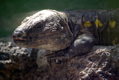
El Hierro has a unique species of giant lizard, Gallotia simonyi. They're about 60 cm long, although most of that is tail. That makes them about the size of an iguana.

La Gomera also has its own species of giant lizard, (Gallotia bravoana) as does Tenerife (Gallotia galloti) and Gran Canaria (Gallotia stehlini). They're 60 cm - 40 cm long, and they're all in the Lacertidae family. A different species was recently discovered on La Palma, but the location's a secret (which is probably wise) and they're only 30 cm long.

On the other hand, you can go and see the ones on El Hierro. There's a breeding station and museum open at Guinea. It's on the main road from La Peña to La Frontera, signposted "El Lagartario"

Thursday, April 16, 2009

The Sacred Garoe

The new Garoé, El Hierro

As the trade winds hit the island, they're forced upwards, and the water vapour, picked up from the sea, forms clouds. This means that El Hierro often has a cloud pouring over the top, much like the cloud waterfall on La Palma. Unlike La Palma, there aren't nearly as many trees to trap the fog in their leaves so that it drips onto the ground, which makes El Hierro much drier.

This makes any tree that does so, very important. At the time of the Spanish invasion, the Garoé was a large tree (a or Ocotea foetens or Til) which grew near the summit of the ridge at the north of the island. It was so important that the Bimbaches (the pre-hispanic inhabitants) considered it sacred, and the water it provided helped them to resist the invasion for a while. Legend says that the secret of the tree's location was betrayed by a local girl who fell in love with a Spanish soldier. Once the Spanish controlled the drinking water supply, the Bimbaches had to surrender, but the girl was condemned to death.

Sadly, the original tree was destroyed by a storm in 1610. Rather surprisingly, a replacement wasn't planted until 1957.

Today it's a beautiful place. You can drive along the track with care, or you can walk about 3 km from the tarmaced road. I saw it in the mist, whch was wonderfully atmospheric, but I'm told when it's sunny, it's lovely in a completely different way.

The last little bit of the path is downhill. You pass a tiny souvenir shop, tucked away around the corner so that you can't see it from the tree. Then you find a series of natural (or perhaps just very, very old pools) near the tree, which is tucked in a hollow in the hill. (I took this photo from the back of the hollow.) I suspect that the original tree was big enough to have its crown well above the sides, so that it would have collected much more water. Nonetheless, it's a special place, and I'm very glad to have seen it.

Saturday, April 11, 2009

The Edge of the World


The western edge of El Hierro used to be the edge of the world. In the second century AD, Ptolemy made it the zero meridian, marking all longitudes east from there. In 1634, France decided it was exactly 20º west of the Paris meridian, and some old French maps mark longitude in both degrees from Paris and degrees from El Hierro.

When they found that El Hierro is 20° 23' 9" west of Paris, they kept the Paris meridian. And an international conference moved it to Greenwich in 1884.

Today there's a monument on the old zero meridian. It really does feel like the end of the world. The whole island's rather dry, and this is the drier end of it, so there's no trees or grass, just scrubby little bushes which look very odd to English eyes. The minor road turns into an unclassified road and then a dirt track. Then we had to park and walk a mile. No houses in sight. The mobile phone had no signal. As we arrived, a couple of people were just leaving in a 4x4, and that was the only other car we saw the whole time.

The monument itself is modest – just a block of concrete with half an iron globe poking out of it. But it was amazing to think that we were the most westerly of the 497,000,000 people in the EU.

Friday, April 10, 2009

Where the Heck is El Hierro?

Map of the Canary Islands

Satellite view of the Canary Islands

El Hierro is the smallest of the Canary Islands, at the bottom left-hand corner of the archipelago which lies off the coast of Morocco (7.7º north and 18.0º west). It's shaped rather like an equilateral triangle that's sucking its cheeks in, and each side of the triangle is only about 12 miles (7.5 miles) long. Just 10,500 people live there, give or take. For all that, it's incredibly varied. You spend a week there and still not see all of it.

The island is volcanic, and still has over 500 visible cones, besides the ones covered by more recent eruptions. Today it forms a three-pointed star, with the highest point rising to 1501 m. The top of the ridge is frequently covered in cloud made by the moisture-laden trade winds being forced upwards by the island.

The island's capital town, Valverde, is 590 m above sea-level, and noticeably cooler. It's a pleasant little town, as long as you're not expecting a major shopping centre.

There are ferries and flights to Tenerife, plus three ferries a week to La Palma (Saturday, Tuesday and Thursday) and one direct ferry from La Palma to El Hierro (Sunday evening).


View El Hierro in a larger map